
More Adventures With Weather Forecasting
It’s autumn, but winter is fast approaching, so that means grim and terrifying headlines about severe weather systems arriving in the UK. You might remember me writing about this last year, when the Daily Express reported in November 2013 that the winter of 2013/14 would be “the worst in 100 years“. Predictions of Arctic blizzards were confronted with the reality of a warm, wet, stormy winter, with terrible flooding.
True to form, in November 2014 the Express reported that the UK was in for a “polar vortex” of catastrophic weather, with “three months of blizzards and Arctic gales”. Once more, James Madden of Exacta Weather was providing the forecast. I’m pleased to see that a description of his model, which relies on observations of the weak jet stream and the level of snow cover in Siberia, is given a bit more coverage in the media.
The evidence would suggest, as Madden predicts, more cold air residing over the UK for some time. However, this isn’t a guarantee, and cold air requires precipitation to make snow. The Met Office made a similar prediction, stating that “wet and windy weather may be more frequent than is typical”, but are substantially clearer as to the limitations of their model. In fact, their statement is worth a read simply to get a sense of how statistics and probability are used to make forecasts, and what the forecast actually means as a result.
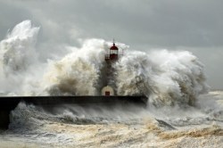
Madden also predicts the approach of low-pressure systems to the coast, potentially causing a repeat of last year’s cataclysmic storm surges. It’s hard to say here whether this is the Express pressing him for information the public really wants to know, or if he is hedging his bets. After all, low-pressure systems approaching the coast are the principal component of all British weather – all it takes are small changes in direction and strength to produce the terrible weather many Britons suffered in early 2014.
On Exacta’s website, Madden claims that low sunspot activity and hence inefficient ocean warming is at the heart of the current weather instability, but without evidence of how these phenomenological features are converted into quantitative predictions, it’s unclear how we should interpret them. Many weather forecasting companies keep their methods secret, as to do otherwise would destroy their business model, which is fair enough when attempting to make a living.
However, this makes it very difficult to compare forecasts from different sources. The forecasts given to the press contain very little quantitative information (again presumably to encourage subscription), so it is unclear how the forecasts that end up in the newspapers relate to those given to subscribers, and consequently to those of the Met Office. Also, it seems more than a coincidence that a “dire weather” forecast is more likely to shift newspapers than an “it’ll be a close to typical winter” headline. I suspect that the newspapers are more to blame in this regard.
The winter ain’t done yet, so it remains to be seen if truly horrible weather is on the way. In Scotland, we’ve certainly had some very stormy weather, and this seems to be becoming the new norm – certainly for the last few years, we’ve been forced to endure hurricane strength winds and travel disruption in December and January.
This year, I am less concerned by the forecasts being made than I am by their presentation in the media. Newspapers should take more care to report the risks correctly, and be more sceptical of sources that don’t reveal their methods, regardless of whether their press release makes a good headline or not. For the time being, readers like you and I will have to remain vigilant (see our How to “Research the Headlines” posts for some tips).
And my advice about winter weather? I would urge caution, of course – British weather has a habit of turning bad very quickly. Be prepared, and check up to date short-range forecasts from the Met Office before travelling.

