
Are we in for a Really Bad Winter? Or how does long range forecasting work?
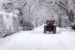
At this time of year, the media is full of dire predictions for the upcoming winter. The Daily Express’ recent headline stated that the Winter of 2013/14 was forecast to be ‘the worst in 100 years‘, with record snowfall and below-average temperatures from November onwards. This headline came from long range forecasts given by Vantage Weather Services and Exacta Weather, private companies that generate forecasts independently from the more familiar Met Office.
What the Media Said
The Express article quotes Jonathan Madden of Exacta Weather to back up its 100 year headline, saying
An exceptionally prolonged period of widespread cold is highly likely to develop throughout this winter and last into next spring. It will be accompanied by snow drifts of several feet and long-lasting snow accumulations on a widespread scale. This period of snow and cold is likely to result in an incomparable scenario to anything we have experienced in modern times.
This assertion is backed up by Exacta’s website. Vantage Weather Services takes a more moderate view, stating that most months will see temperatures ‘on or around the average’. While they expect precipitation to be relatively high, this does not appear to translate into the disruptive snowfall that plagued the UK in 2010/11.
The Daily Star published a similar story, relying on MeteoGroup for their predictions, which focused on shorter range forecasting.
The Huffington Post published a fairly sardonic counterpoint to the Express, casting aspersions on the methods that these companies use to provide their long range forecasting, in particular Vantage Weather Services. They went to the Met Office for a quote, and their spokesperson’s response speaks volumes. So, why are there two vastly different views on the winter weather? To find this out, we will need to learn more about how the forecasting process.
How are these forecasts made?
A quick check of Exacta’s website shows that they do not use the same methods as the Met Office:
No meteorological or climate models have been used in the production of the following long-range weather forecasts. All forecasts are produced on a number of personal observations and calculations, that also include; solar activity, ocean behaviour, and historical weather patterns from my own unique collective data.
Without any further information, it is difficult to assess how accurate these model predictions can be. While Exacta’s website lists a series of accurate predictions, there is not an equivalent list of inaccurate predictions, which some futurists believe is essential for advancing our predictive power. Equally, weather forecasters rarely list their inaccurate predictions, and typically only address them when media pressure demands it (although the Met Office is more upfront about uncertainty).
Exacta links current cool wet summers and more severe winters to a change in Solar activity. In particular, they state an apparent decrease in sunspot activity points to the development of a new Maunder minimum. The last Maunder minimum did indeed coincide with a period of cold winters in Northern Europe, and there is some (if perhaps not enough) evidence from computer models for a link between low sunspot activity and cold European winters.
Also, the jet stream which connects America and Europe, separating cold Arctic air from warm Atlantic air, is known to fluctuate (the video at the link above is an excellent demonstration of this). If the jet stream tilts downwards, the UK can be flooded by the Arctic air, dropping temperatures.
Exacta uses these facts to generate its forecast, but how this is mixed with the other factors mentioned on their site is unclear, so the jury is out.
The Met Office do not agree with the proclamations made by Exacta and Vantage Weather Services. In a statement responding to an earlier article in October, they caution against overly trusting forecasts of this type:
While we have seen a return to more normal, cooler temperatures for this time of year, this is no indication of what we can expect over the next four months with regards to temperatures and when we might see snow. It is far too early to tell.
Ultimately, we’re heading into winter and it is perfectly possible that we will see the whole range of weather that we get in winter at some point over the coming months, including snow and freezing temperatures, but also heavy rain, windy weather and mild conditions too.
So how does the Met Office generate its forecasts, and why is it incapable of making the forecasts that these other companies make?
According to the laws of physics, if you know the state of a system, you can use those laws to show what the state will look like in the future, and this is what the Met Office tries to do. The Met Office takes data from weather stations across the country, to generate a model of the air and precipitation over the UK at a moment in time. It then uses a computer simulation, programmed with the laws of physics to attempt to predict how the air will behave in the future.
So why do they not have such strong faith in their predictions? The answer is chaos. The laws of physics will let you predict how a system behaves if you know the system well enough. And therein lies the problem. It’s sometimes referred to as the ‘butterfly effect‘: a butterfly flapping its wings gently moves the air around it, setting up a chain of motion that could seed a weather system on the other side of the planet. As the Met Office doesn’t include butterflies in its simulation, and we can’t know the state of the land and air in the UK down to the individual molecules it’s made of, chaos will grow in the system until the weather is completely unpredictable. This is why the Met Office forecasts typically stop after 5 days, and why a forecast can change rapidly in the 5 days leading up to the day’s weather.
To make a long range forecast, these models won’t work, and instead companies must turn to statistical models based on previous winters and summers, possibly including the physics I’ve already discussed in this post. Every forecaster will give different amounts of credence to different physical processes, and long range forecasting becomes a mixture of art and science.
So what is the moral of the story?
A healthy pinch of salt is required. At the end of the day, any long range forecast is simply a statement of the odds, and each bookmaker has their own personal method for setting those odds. Now, the bookmaker’s livelihood depends on setting the odds so that they’ll make money, so each weather forecaster has a vested interest in getting it right as often as possible, which is good. The Met Office have had their own failures at prediction (as all predictors do), and the weather is a tricky business. There’s no harm in preparing for the worst, but at the same time, be careful how much money you put down on a White Christmas.
Share this:

Trackbacks & Pingbacks
- Are we in for a Really Bad Winter? Or how does long range forecasting work? | Scientist in a Skirt
- Looking Back on Research the Headlines in 2013 |
- Our 6 month anniversary: looking back at headlines |
- How Well did Long Range Weather Forecasters Do this Winter? |
- More Adventures With Weather Forecasting |

Reblogged this on Well-Bred Insolence and commented:
If you haven’t been following Research the Headlines, where Young Academy of Scotland members investigate how research is portrayed in the media, then check out one of my recent posts on weather forecasting. I’m managing their posts this month, so feel free to suggest any stories or topics you want us to cover!